Long before the human occupation of the Amazon, the South American scenario was formed, where the Amazon basin is located.
The formation of the subcontinent
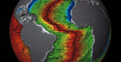
Specialists believe that the land mass known as Pangea began to crack, due to the action of tectonic plates, 400 million years ago. The earth’s crust fragmented, forming the continents.
December 15, 2024

The Shaman War
April 12, 2020

Dinosaur fossils, giant plants and animals in the Amazon Rainforest
April 10, 2020
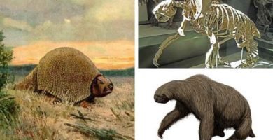
Giant animals of the Cenozoic Era in the Amazon Rainforest
April 8, 2020
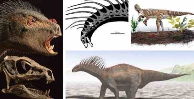
Dinosaurs in the Amazon Rainforest
April 7, 2020
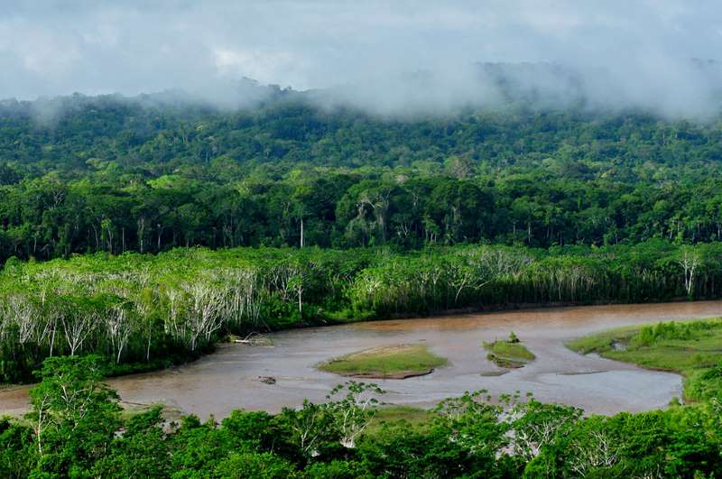
Brief history of the Amazon Rainforest landscape
Around 240 million years ago, two large blocks, now known as Asia and America, separated. Due to the occurrence of glaciations, a bridge was formed connecting these two parts: it was the Beringia bridge, which appeared and disappeared, according to the magnitude of the glaciations. In the first glaciation, about 150,000 years ago, the corridor was formed, remaining active for about 4,000 years. With the second glaciation, between 25,000 and 10,500 years ago, the bridge reappeared. It was about 1,500 m wide, and between 30 and 50 m deep. It was initially believed that animals and plants passed from Asia to North America over this bridge during the second glaciation. Plants do not walk, but pollen from flowers and seeds (sexual reproduction) or stems (asexual reproduction) can be moved from place to place.
It is believed that the first human migrations to America passed through this land and ice bridge. Not from a single source, but from several. They comprised at least two large groups: those coming from northern Siberia and those coming from northeast Asia, probably the first Americans. Others believe that this bridge was not the only way, and there are discussions about the period in which the migrations occurred. It is estimated that the bridge was an uncertain and, for some, impracticable route for a long period. There was no vegetation, no shelter from the high temperatures, and no food was available along the way. Some indicate that another route of entry was along the shores of what is now the Pacific Ocean.
Then, around 240 million years ago, the fracture that separated North and South America occurred. Between 150 and 120 million years ago, Africa and South America separated, and the Atlantic Ocean was defined, emerging between these two parts. Much later, some 2.3 million years ago, the Isthmus of Panama emerged, allowing the exchange of living beings between North and Central America and South America, and separating the oceanic waters: on one side, those of the Pacific, and on the other, those of the Atlantic. The first human migrations to South America arrived there from North America.
2 major geological events
It is also important to note that in the geological history of South America there are two major events, which constituted the two great South American geographic features: the Andes mountain range and the Amazon basin. The Andes Mountains, the longest mountain range on the planet at about 8,000 km, were formed about 120 million years ago by the subduction, or sliding, of the Nazca plate beneath the South American shelf plate, producing a pressure that caused the initial uplift of the mountain range. When the eastern part of the Andean mountain range was uplifted, an immense lake of almost 1 mm of km 2 was created, Lake Pebas. When its waters emptied into the Atlantic Ocean, due to the final uplift of the Andes, some 2.4 million years ago, the Amazon area of about 7,000 to 7,500 km2 was formed.The Amazon basin is the longest and most abundant river in the world, which directly or indirectly collects more than 1,000 tributaries, some of which are very important for their length and flow, such as the Putumayo, Napo, Madera, Negro, Ucayali and Marañon rivers.
The occupation of the subcontinent
There are no precise dates on the formation processes of the South American subcontinent and its major geographical features, as we have seen, nor on its occupation process.
There are, however, two theories about his occupation. The late occupation, between 14,000 and 12,000 years ago, postulated by Thomas Lynch, and the early occupation, more widely accepted, which places the occupation of the subcontinent between 30,000 and 25,000 years ago, during the late Pleistocene.
3 lines of research
Some research, mostly conducted in 2018, applying the method of population genetics, has shed some light on the process of occupation of South America.
The first is that they showed that the occupation was carried out rapidly and unevenly, and in several waves. By 14,400 years ago, humans had already settled at the Monte Verde site, located in the extreme south, in Chilean Patagonia. Research led by Danish researchers, published in the journal Science, based on the examination of 15 ancient South American genomes, found that six of them were older than 10,000 years. They were small groups of hunter-gatherers who moved quickly. Along the way, individuals from both waves of migrants mixed with each other.
Other research, published in the journal Cell, reported that there were at least three north-south migratory waves from Alaska that had crossed the Bering Strait, or Beringia Bridge, some 15,000 years ago.
The third research, this time published in Science Advances, established that the first settlers, who stayed in the Andes, adapted to the harsh living conditions of the Andean highlands and to the hypoxia, or lack of oxygen in the air, where they had arrived some 12,000 years before. The research also investigated the vulnerability of the American populations, especially with the initial arrival of the European colonizers since the 16th century, who brought some diseases unknown to the indigenous people. They determined that the impact of the diseases spread by the colonizers decimated, together with the aggressions of the conquest, about 90% of the indigenous population living in the lowlands, and 27% of those living in the Andean highlands.
Occupation and development of the Amazon Basin
In order to understand and date the ancient processes of occupation of the Amazon rainforest, it is necessary to resort to evidence provided directly by archaeology, complemented by other social sciences. Unfortunately, the Amazon region has been little studied by archaeologists and anthropologists. The greatest research effort was carried out in the Andean regions, and in particular in what has been called Nuclear America, the scene of the great indigenous civilizations of the Americas. In the case of South America, the effort concentrated on the study of the Inca culture and its antecedents, especially since the 12th century. So much of the history of the previous occupation remains obscure. This makes it difficult to protect the vast Amazon region: you don’t really love what you don’t know.
This underdeveloped and asystematic vision of the Amazonian reality, and its understanding by the Western academic world, slowly began to change in the twentieth century. Before, the Amazon was a wild, orphaned territory, exploited by the big rubber barons and illegal mining, who enslaved “ignorant” indigenous people.
2 fundamental works
From the mid-twentieth century onwards, two fundamental works were produced, both related to his doctoral theses, which brought new perspectives of analysis and allowed us to begin to understand the process of occupation of the Amazon. From them, and from their followers and critics, the interest of the social sciences in Amazonian societies grew.
1. “Amazonia: Man and culture in a counterfeit”.
The first work corresponds to the research carried out by the American archaeologist Betty J. Meggers (1921-2012), who worked with her husband Clifford Evans (1921-1981). Meggers, in his doctoral dissertation(Amazonia: Man and culture in a counterfeit) presented in 1962 at Harvard University, postulated that the Amazonian environment closely conditions culture and cultural diversity through two main ecological niches: the vast “terra firme”, of the non-floodable highlands, rich in resources but widely dispersed, and the “várzea” zones, the narrow floodplains or flood banks, where periods of scarcity and abundance alternate, depending on the rainy and dry seasons, which determine whether or not the rivers, and their associated resources, rise or not. Each niche, according to Meggers, presents its own type of cultural adaptation. The groups that adapt, in small groups, on the mainland, because the environment does not provide them with greater resources for their subsistence and development of large populations, and that of the larger and more socio-politically complex groups located in the more productive várzeas. In both environments, war is an adaptive strategy of population control, using witchcraft or revenge to obtain women and resources, or war raids in the case of the Varzee to obtain slaves. There are two central points in Meggers’ thinking, which he maintained to the end of his life. One is that in the Amazon there were not sufficient conditions for the development of societies with a certain political, organizational and economic complexity. The rapid weathering of the soil, and its nutrient poverty, were not conducive to the development of a far-reaching sedentary way of life. The other, related to the first, is that, at some point, and if there was one, the impetus for Amazonian development came from the Andean highlands or northwestern South America (Meggers, 1999).
2. The Upper Amazon
The second corresponds to the work The Upper AmazonLathrap (1927-1990), researcher at the University of Illinois, who left a great work and a group of brilliant disciples who made interesting contributions to Peruvian Amazonian archaeology: Thomas Myers, Warren de Boer, William Allen, J. Scott Raymond, Peter G. Roe. For Lathrap, development should not be sought outside, in the Andes, as Meggers suggested, but inside, in the Amazon itself. And more specifically in the central part of the basin, in the confluence zone of the Negro, Madera and Amazon rivers, where, he says, large populations have been settled for at least 5,000 years. In this region, plants were domesticated, local resources were managed with great inventiveness, and a nucleus of dispersion of a series of agricultural-ceramic societies was produced, which later spread to other areas of the Amazon basin, the Orinoco River basin and the Caribbean. But that development occurred, according to Lathrap, in the fertile floodplains or várzeas. Thus, he assures, supported by the research of Cruxent, Rowe, Heckenberg and Neves, that large populations settled in this part of the Amazon. With this assertion, Lathrap confronted the tropical forest culture model, developed by Julian Stewart and Robert Lowie, which holds that Amazonian cultures were limited in their development by an unproductive environment and simple technology. Under these conditions, it was very difficult to obtain a surplus that would allow the accumulation of material “capital”, the division of labor and specialization. This would have limiting consequences on the social stratification and political organization of these communities.
The scientific discussion now turned to aspects related to the population carrying capacity of the Amazon and the level of complexity of its societies, whether they corresponded to isolated and mobile bands, chiefdoms, lordships, chiefdoms, chiefdoms or small states.
The work of geographer William M. Denevan deals with the carrying capacity of the Amazon regions. According to Denevan, the carrying capacity of the greater Amazon (including the Orinoco River basin and Guyana) is 6,800,000 inhabitants, with a density of 0.7 inhabitants/km2, which, later, in 1996, reduced to 5,487,000 people. Denevan had made studies, with Alberta Zucchi, in the central plains of the Orinoco. Then Stephen Rostain found in Guyana, in 2013, structures of an agriculture based on elevated and draining fields, as well as agricultural beds, indicative of the application of a technology capable of sustaining a large concentration of population.
A major boost to Amazonian archaeology came from the American archaeologist Anna C. Roosevelt, between 1987 and 1994, with her discoveries at the Parmana site along the Orinoco. Roosevelt postulates the introduction of maize around 800 A.D., to store food and enrich the diet, and suggests the existence of chiefdoms in the region (Chiefdom in the Amazonas and Orinoco, 1987). Another great contribution was made with his excavations of the Marajoara phase (400-1,300 A.D.).
The vision of the Amazon with a few large population centers is reinforced by the discovery of anthropogenic forests in Santarém, in the Lower Amazon, Brazil. These forests result from the use of anthropogenic soils or Amazonian dark lands (TOA), known as terras pretas do indio, used by indigenous people to increase soil fertility, which is an indication of a certain degree of social development. The TOA is soil that has incorporated, by human action, numerous ceramic fragments, ground animal bones and charcoal fragments, and are indicative of the size and density of the populations that make them. William M. Denevan pointed out in 1996 that this black soil was transported to the highlands to compensate for the nutrient poverty of their soils. Other researchers such as Heckenberg, like Lathrap, argued that only várzeas areas are capable of harboring large populations. Heckenberg and his team discovered settlement patterns in the Upper Xingu, Brazil, dating between 1200 and 1600 AD, that show large-scale transformations of the Amazonian landscape. For Heckenberg, the existence of large populations is conditioned by several factors: the regional articulation of permanent settlements, the use of water resources, the intensive agriculture of cassava and fruit trees, and the existence of social hierarchy systems, which would allow the use of abundant water resources and the application of intensive agriculture, with the management of anthropic soils. The presence of these elements would favor the existence of chiefdoms. But it is difficult to prove this assertion, because of the difficulty of obtaining archaeological evidence. Lathrap noted in 2010 that Amazonian crops focused on roots such as cassava, which do not leave vestiges as they do in a cereal culture, producing hard grains that leave an imprint in the wet clay of pots before they are fired. Indirect evidence must be sought, such as the utensils and methods used for the preparation of bitter yucca, comales or budares for cooking, or animal parts such as teeth, toucan beaks, bone scales like that of the paiche (Arapaima gigas)a large osteoglossiform fish, whose hard scales are used for cutting, or its tongue as a paddle.
The existence of the cacicazgo corresponds to a form of political organization with a center of power or small multi-communal societies. This concept was developed by anthropologist Marshall Sahlins (1958) in his research in Indonesia. The chieftainship is established on the basis of the status and prestige of a person in the group through the practice of redistributing resources among the rest of the members of the group. In the case of the Amazon, a power structure was necessary for the control of the riverine areas or várzeas, for which there was great competition among the different indigenous groups. And the figure of the paramount chief probably emerged, as pointed out by Roosevelt (1999) and Cavalcante Gomes (2007). Apparently, this was the case in Santarém, the capital of a sort of Tupi-Guarani-speaking Tapajós chiefdom that developed between 1250 and 1650 A.D. According to Rostain (2013), this organization, rather than a chiefdom, was a regional system with powerful chiefs in each village that ensured regional control.
Recommended basic bibliography
- Cabrero, F. 2017. On bands, tribes and chiefdoms: an approach to Amazonian archaeology. Atlantic-Mediterranean Journal, 11, 85-96. University of Cadiz.
- Cartay, R. 2016. The Peruvian Amazon table. Ingredients, corpus and symbols. Lima: Universidad San Martín de Porres.
- Cavalcante Gomes, D. M. 2008. Cotidiano e poder na Amazonia pre-colonial. FAPESP/ edusp.
- Denevan, W.M. 2003. The Native Population on Amazonia Reconsidered. Revista de Indias, Vol. LXIII, 227, 175-188.
- Heckenberg, M.2005. The ecology of power. Culture, place and personhood in the Southern Amazon. New York: Rouledge.
- Heckenberg M.; Goes Neves, E. 2009. Amazonian Archaelogy. The Annual Review of Anthropology, 38 251-266.
- Lathrap, D. W. 1970. The Upper Amazon, Spanish edition available. 1970. The Upper Amazon. Lima: Instituto Cultural Runa/ Chataro Editores.
- Meggers, B. J.1999. Ecology and Biogeography in the Amazon. Theoretical approaches to archaeological research.. Quito: Abya-Yala.
- Meggers, B. J. 1971. Amazonia: Man and Culture in a Counterfeit. Paradise. Spanish edition available: 1991. Amazonia, Man and Culture in an illusory paradise. Mexico: Siglo XXI Editores.
- Roosevelt, A.C. 1999. The development of prehistoric complex. Amazonia, a tropical forest. In: E.A. Bacus, I.J. Lucero , J. Allen (eds.). Complex Politics in the ancient tropical world. Arlington: American Anthropological Association, 13-34.
- Roosevelt, A. C. 1993. The Rise and fall of the Amazon Chiefdom. L’Homme, 126-128. XXXIII (2-4), 255-283.
- Roosevelt, A.C. 1980. Parmana: Prehistoric Maize and Manioc. Subsistance along the Amazon and Orinoco. Oxford: Academic Press.
- Rostain, S. 2013. Islands in the rainforest. Landscape Management in Precolumbian Amazonia. Westnut Creek: Left Coast Press.
- Sahlins, M. D. 1958. Social Stratification in Polynesia. Washington: University of Washington.
- Schaan, D. 2012. Sacred Geograhies of Ancient Amazonia. Historical Ecology of Social Complexity. Walnut Creek: Left Coast Press.
- Ugalde, M.F. 2011. Towards the demystification of the Orient. Archaeology in the Ecuadorian Amazon Basin. Indiana, No.28, 59-78.
- Willey, G.R. 1971. An Introduction to American Archaelogy (Vol. 2: South America). New York: Prentice Hall.
Dr. Rafael Cartay is a Venezuelan economist, historian, and writer best known for his extensive work in gastronomy, and has received the National Nutrition Award, Gourmand World Cookbook Award, Best Kitchen Dictionary, and The Great Gold Fork. He began his research on the Amazon in 2014 and lived in Iquitos during 2015, where he wrote The Peruvian Amazon Table (2016), the Dictionary of Food and Cuisine of the Amazon Basin (2020), and the online portal delAmazonas.com, of which he is co-founder and main writer. Books by Rafael Cartay can be found on Amazon.com
This post is also available in:
![]() Español (Spanish)
Español (Spanish)