How was the Amazon formed? What is its geological origin? What was the territory like in the time of the dinosaurs? What factors led to its high biodiversity?
We will use the fossils to investigate the changes in the landscape, and then we will situate the dinosaurs and the time in which they existed. But we will only refer to the natural landscape, since the cultural landscape, the one built by humans, did not yet exist. I invite you, then, to understand what the Amazon landscape was like and how it changed over time.
Once we find the fossils, that is to say, the traces and the preserved fragments of the flora and fauna of that time, the dinosaurs will be waiting for us there.
How were the continents formed?
There have been several mega-continents over time (Columbia, Rodinia, Pannotia).
The last known was Pangea (from the Greek prefix pan, all, and the term gea, earth).
Pangea was a single block of land stretching from the South Pole to the North Pole, and organisms could migrate from one side to the other.

This megacontinent fragmented in the Mesozoic era into two large masses or continents.
Geologists say that this occurred at the end of the Triassic period (about 230 million years ago) and the beginning of the Jurassic period (190 million years ago).
The two continents that emerged were Gondwana in the south and Laurasia in the north.
They were separated by an immense sea called Tethys.
But they were not compact blocks. There was, for example, East Gondwana (Antarctica, India, Madagascar and Australia) and West Gondwana (Africa and South America).

These continents continued to divide into other large blocks or subcontinents.
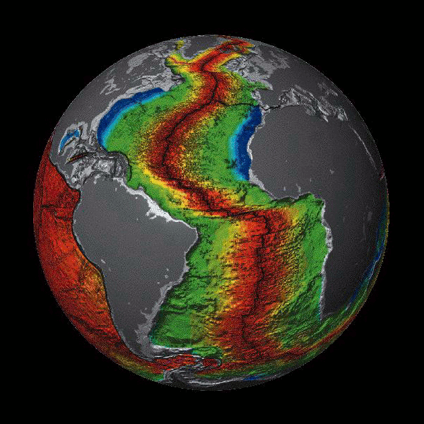
The theory of continental drift indicates that these two large continents continued to move over time, generating the continents we now know.
North and South America converged, united by the “hinge” of the Isthmus of Panama.
How was the Andes mountain range formed?
The displacement of South America, as it separated from Africa, caused its western edge to overlap the adjacent oceanic plate (the Nazca plate).
By compression, it lifted and folded that edge, producing a lifting of the crust, and the Andes were born.

Geological origin of the Amazon
During the Miocene, the Andes mountain range began to rise, and as a consequence, an adjacent depressed zone was formed, which would later constitute the Amazon basin.
Without the emergence of the Andes, the Amazon basin would not exist.
At the beginning of the long geological and hydrological history of the Amazon basin there was a vast and complex aquatic system, half lake and half estuary, which ran parallel to the Andes and connected with the Caribbean Sea.
A rich biodiversity developed in this environment during the Eocene and middle Miocene (between 55 and 11 million years ago).
The Andes Mountains acted as a barrier that conditioned the evolution of the Amazon basin.
The Andes added about 2 billion tons of sediment to the basin each year, most of which was trapped in the transitional part between the Andes and the adjacent depression.
The mountain range hindered the atmospheric flow in the southern hemisphere, creating a strong climatic contrast, with a humid Amazonian slope and an arid Pacific slope.
The Andes also caused an acceleration of the wind from the north on the eastern edge, facilitating the transport of humidity from the tropics to the south of the continent, producing areas of abundant rainfall.
As a consequence of this history of geological changes, a vast hydrological system was developed some 10,000/12,000 years ago, formed by the Amazon River.

(Public domain)
The origin of the Amazonian fauna
During each major period, changes occurred in the terrestrial and freshwater fauna that moved from one place to another.
As major geological changes took place, there was a dynamic biotic exchange of species migrating from North America through Central America to South America, taking advantage of the emergence of the Isthmus of Panama.
Geological, climatological and paleontological studies speak of these changes.
By studying DNA changes in fossils, the origin of the different species in the basin can be dated approximately.
Based on those fossils, the specialists argue that, in all probability, most of the current Amazonian biodiversity originated during the Miocene and Pleistocene, that is, in the last 20 million years.
Three fundamental factors
The evolution of the Amazonian landscape and life has been the consequence of at least three major events over time.
- First came the separation of Africa and South America from Gondwana.
- Second, the emergence of the Andes Mountains and its impact on the depression that would later become the Amazon basin.
- The third was the change in the orientation of the Amazon River, which impacted the rivers of the basin and their contributions, changing the mouth of the river from the Pacific to the Atlantic. This modification produced geological-climatic alterations and contributed to shape the Amazonian fauna and flora.
From the Pleistocene to the Miocene: withdrawal of Pacific Ocean waters from present-day Amazonian territory
The Amazonian depression extends between two large archaean shields: the Guiana shield and the central Brazilian shield, which have not been covered by the sea.

These shields are continental regions formed by granitized rocks, very old and stable, resulting from vertical tectonic movements, not horizontal or folding.
In the Pleistocene, that depression was flooded by the sea, which formed a large gulf open to what is now the Pacific Ocean.
On that side, to the west, South America was connected to Africa, and the gulf closed in the east.
In this cavity flooded by the sea, sediments up to 3,000 m thick were left behind, which underlie the entire Amazonian sedimentary basin.
The sea retreated from this cavity during the Mesozoic, a geological era ranging from 225 million to 55 million years ago, in its three periods: Triassic, Jurassic and Cretaceous.
This is an important era for our explanation, since it is known in zoology as the era of the dinosaurs, and in botany as the era of the cichlids, which served as food for the herbivorous non-avian dinosaurs. Despite the dinosaurs’ widespread extinction, cichlids still exist in North, Central and South America and the Caribbean, and in other parts of Asia and Africa.
As the sea retreated in the Mesozoic, the Amazon Basin emerged. Rivers draining to the Pacific, such as the Amazon, then began to flow eastward.
Related Posts

This post is also available in:
![]() Español (Spanish)
Español (Spanish)